Latest Issue
 
Windtech International March April 2025 issue
 

Login


FOLLOW US AT

follow

 Follow us at BlueSkyFollow us at BlueSky


follow


What Is the Industry Willing to Accept to Confront It?
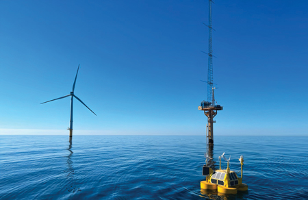
Eolos fig 1Floating lidar systems have revolutionised the offshore wind industry by enabling the bankability of projects at a fraction of the original cost – successful wind resource assessment campaigns are essential for the economic viability of the wind farm development process. However, one parameter measured in such campaigns – turbulence intensity – is at the centre of debate. Its accuracy, with respect to the traditional definition, is known for not reaching industry standard levels, representing a serious problem because of the lack of consensus within the industry on how to address and solve this matter. The complexity of this phenomenon means that there is no optimal solution. Several suboptimal alternatives are currently under development, but there is not yet a clear picture of which is the right option. However, this might be about to change.

By Adrià Miquel and Giacomo Rapisardi, Eolos Floating Lidar Solutions, Spain

One of the most complex phenomena to describe scientifically is turbulence. For wind, a turbulent stream can be understood by measurement of the wind speed variability over time and space. This variability, adjusted to the wind industry’s standard measurement timescale of 10 minutes, is commonly referred to as turbulence intensity.

The Effects of Turbulence in Wind
Turbulence in wind has considerable effects on multiple segments of the technical value chain, which can be grouped into two main categories: the impact on the loads supported by wind turbines and the energy produced by wind farms. The former group relates to wind farm siting aspects, fatigue effects on structural elements of wind turbine generators, and the extreme conditions they support. Onshore sites are the most affected by the siting constraint, as terrain complexity plays a crucial role in the turbulent behaviour of wind. An accurate characterisation of loads allows improvement of both the cost, through effective design, and reliability during the operation phase. In terms of energy production, having a good interpretation of turbulence intensity allows optimisation of the wind farm layout by providing a better understanding of turbulent wakes, thus minimising the farm’s energy losses. Furthermore, at the individual wind turbine level, there is also room for improvement in the power curve when accounting for turbulence.

Evolution of the Measurements Industry
The problem lies in how the industry standards and recommended practice documents related to the design of wind turbine generators have been developed compared with what is currently delivered by the offshore wind industry. These methods and procedures were produced based on wind measurements made by anemometers because that was the only available technology at the time. However, the adoption of wind lidars in general, and floating lidars in particular, has transformed the way in which wind is measured. Nowadays, providing accurate 10-minute average wind speed and direction is not a problem for lidars; however, to accurately measure higher order parameters such as turbulence intensity continues to be a challenge. While not raising uncertainty for the primary wind parameters, i.e. the 10-minute average of wind speed and direction, there can be discrepancies for higher order parameters such as turbulence intensity.

The Floating Lidar Turbulence Intensity Problem
The differences in turbulence intensity measurements delivered by traditional anemometry and floating lidars stem from two main factors: the motion induced by waves on buoys and the difference in the measuring principle between anemometers and lidars. On the one hand, cup (or sonic) anemometers measure the wind at a single point in space and therefore can only capture the temporal component of wind variability. On the other hand, lidars measure the wind over a volume, hence accounting for both the temporal and spatial components of wind variability. A lively discussion is underway regarding which type of instrument – anemometer or lidar – delivers the more precise characterisation of turbulence for wind turbines, but this debate merits a separate discussion. At the 10-minute level, the wave-induced motion effect is averaged out for the first-order parameters, since waves are harmonic; nevertheless, this is not true for higher order effects such as turbulence.

Eolos fig 2Current Industry Practices Dealing with Turbulence Intensity
The industry is conscious of this problem and has been acting accordingly. To date, floating lidar turbulence intensity measurements have been rarely used or even considered in offshore wind resource assessment campaigns. Until now, developers have had to resort to data from met masts. This, however, poses a series of other problems: 1) met masts are frequently located a few hundred kilometres away from the actual development area, 2) often even being based onshore; 3) measurements might not cover the same time period as the wind resource assessment campaign; 4) measurement heights are frequently unavailable above 100 metres for offshore masts, while offshore wind turbine hub heights now reach 160 to 170 metres. All these elements exert immense pressure on the industry to develop solutions that enable the use of floating lidar turbulence intensity measurements. Several joint industry projects and consortiums have been created, gathering experts and fostering collaboration between stakeholders. Moreover, a series of private innovative solutions are starting to emerge.

Novel Solutions
One of the most widely implemented solutions is to compensate the wind measurements by accounting for the wave-induced motion via a deterministic approach that barely introduces uncertainty into the corrected measurements. Despite its robustness as a solution, it only deals with the motion part of the problem, completely disregarding the lidar volumetric effect, thus obtaining the equivalent measurements of a fixed lidar. As there are no means to accurately measure what occurs in the lidar probe volume, there is no deterministic solution for the lidar volumetric effect. That restricts the range of feasible solutions to the modelling field. Model-based solutions of turbulence intensity can follow different approaches. On one side of the spectrum, there are the classic physical models that resolve the atmospheric–fluid mechanics equations, which come with a high degree of uncertainty. On the other side of the spectrum, the data-driven correction models are becoming a firm alternative facilitated by the latest advancements in computer science.

Eolos Machine Learning Solution
It is well known that the offshore environment significantly reduces the number and intricacy of wind-forcing phenomena, as those related to the complexity of the terrain are negligible. The characterisation of offshore phenomena is substantially simplified to the extent that they can be measured by floating lidar systems and their auxiliary metocean sensors. This combination enables the correction of turbulence intensity measurements through the use of data-driven approaches, since large amounts of measured data can serve to train algorithms using established machine learning techniques. Eolos Floating Lidar Solutions has developed a machine learning model capable of reproducing met-mast equivalent turbulence intensity estimates for a wide variety of environmental conditions.

The model, based on a gradient-boosted decision tree, a state-of-the-art machine learning framework, has been trained with more than 35 input features either measured directly by the FLS200 – the Eolos floating lidar system – or inferred from the measurements. In total, more than three years of data, gathered in 29 verification campaigns in which the floating lidar systems were measuring alongside fixed offshore met masts (see Figure 1), have been used to train the model. These validation campaigns span over seven different sites distributed in Europe, North America and Asia. The variety of input parameters, the amount of data used and its geographical diversity build a wide envelope of environmental conditions, providing the model with the information necessary to determine the complex relationships between environmental conditions and turbulence intensity. The turbulence intensity corrections obtained by the model are consistent over several geographies and environmental conditions (see Figure 2).

Trends and Acceptance of Novel Methods
By setting key performance indicators and acceptance criteria to determine the robustness and uncertainty associated with any turbulence intensity correction method, several initiatives have already started to work towards determining whether the extra uncertainty of turbulence intensity estimates introduced by this class of models is larger or smaller than the current met-mast alternative.

However, after having observed the potential of some of these methods, the necessity arising from this unresolved issue, and recent moves in the offshore wind industry, the real question should be: When will the acceptance of such correction methods be generalised among stakeholders? While not having an exact answer, the authors believe it will not be long until there is a generalised consensus on the adoption and implementation of turbulence intensity estimates measured by floating lidar systems and corrected by machine learning.

Biography of the Authors
Adrià Miquel has MScs in both industrial engineering and environmental engineering. In 2017, he obtained his PhD at the University of Bologna on wave energy conversion. In February 2019, he started working at Eolos, where he currently leads the data services department as Chief Scientist. Adrià has published 13 articles in international scientific journals and conference proceedings.

Giacomo Rapisardi has a BSc in physics and an MSc in theoretical physics. In 2019, he completed his PhD in complex networks at IMT (Lucca). Between 2019 and 2022, he served as a postdoctoral researcher at URV (Tarragona) and BSC (Barcelona), concentrating his research on developing models for real-life complex systems. Since 2022, Giacomo has been employed as a data scientist at Eolos.

Contact Details
Eolos Floating Lidar Solutions
Polígono Industrial Plà d’en Coll
Calle Segre, 12
08110 Montcada i Reixac
Barcelona
Spain

www.eolossolutions.com

 
Use of cookies

Windtech International wants to make your visit to our website as pleasant as possible. That is why we place cookies on your computer that remember your preferences. With anonymous information about your site use you also help us to improve the website. Of course we will ask for your permission first. Click Accept to use all functions of the Windtech International website.